We all know how great Avios are. We have all seen the distance based chart below: 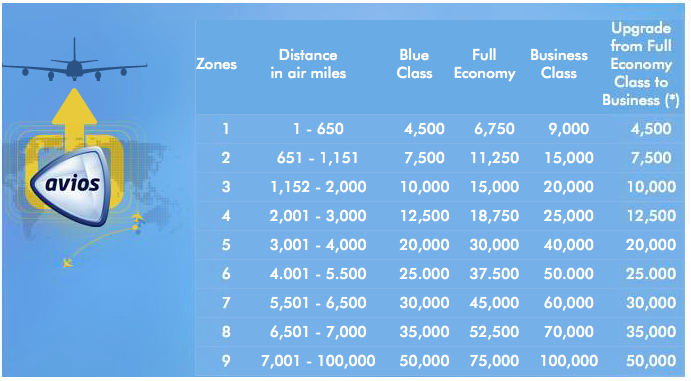
Usually, you have a destination in mind and check to see how many Avios it takes to get you there. For example, let’s say you live in Chicago and want to go to Toronto. That’s a distance of 436 miles according to gcmap.com, so according to the award chart above, it would cost only 4,500 Avios to take that one-way flight (on American Airlines), as opposed to say 12,500 United miles on United Airlines, a savings of 8,000 miles.
However, what if I wanted to know all the destinations from Chicago where I could go for 4,500 Avios. Put another way, what are all the destinations from Chicago that are within a 650 mile radius. The reason why someone may want to know this if their travel plans are fairly open, or they want to strategically use their miles in planning a trip.
The British Airways website doesn’t have this option and I can’t think of any other website that provides this information.
However, you can do this yourself with the help of GCmap.com. I think it’s a pretty cool website that calculates flight paths, distances, and draws awesome maps that you can use on your website.
For example, the image below is ORD with a 650 mile radius with Toronto well within it.
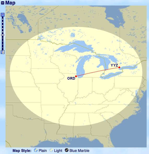
As you notice, cities and states are not listed. If you know your geography well, you can get an idea of where you can travel. If you don’t know your geography, just pull up google maps in a side window to do some comparison.
How to do this:
- Go to gcmap.com
- Click on the “map” button
- Next at the bottom of the page, in the box titled “Map Ranges,” type in the distance and the airport as follows: “650miles@ORD” and then click “Draw map”
- The default for entering this data is “9380nm@LHR.” Notice the “nm” which stands for nautical miles which is not what you want. You want to enter “miles” which is statute miles as in the Chicago example in step 3. You can find the difference between nautical and statute miles here. The distance traveled and the frequent flyer miles that you get awarded by an airline are based on statute miles.
- Once you have an idea that your destination airport is in the zone you are looking for, just verify by typing that in the “Path” box. Example (ORD-YYZ)
This will be most beneficial for OneWorld Alliance hubs. Here’s a map of London Heathrow with a 650 mile radius, 1151 mile radius, 2000 mile radius (corresponding to zones 1 through 3 on the Avios award chart).
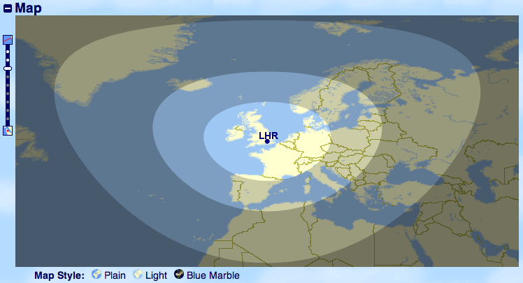
This makes it easier to see where you can travel for 4,500 Avios, 7,500 Avios, or 10,000 Avios. It certainly beats looking up each destination individually.